Return to Site Guide Index
Site Name Carn Brea
Nearest Town Redruth 
O.S. Ref:  SW 685 407
Wind Direction:  NNW-N
Wing Type:  HG & PG 
RAF Ref:  3.004
Access: BHPA Members Pilot Level: Pilot 
Resident Club: KHPA Club Contact: Alan Phipps. Tel: 01872 27 38 39 
Site Warden: Graham May 01209 84 33 80
Site Description: A rough and rocky hill with holes and pits covered by gorse and ferns.
Altitude:720 feet Height Top to Bottom: 300 feet.
How to get there: Start from the village of Carnkie (2 miles SW from Redruth - there are at least two other Carnkie villages in Cornwall) Proceed west and for the turning to the right sign posted Carn Brea.
Vehicle Access & Parking: Difficult but with due consideration for the public and leaving landing areas clear.
Rules and Restrictions:
Rigging Notes: Use common sense and consideration for others.

Marshalling: Use common sense and consideration for others.

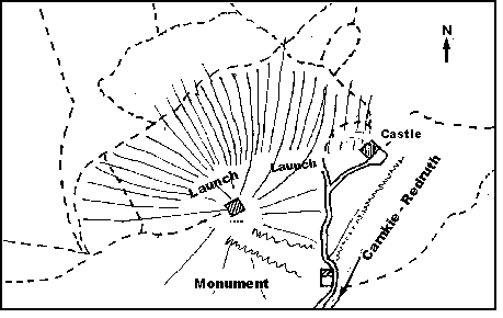
Launch Notes: Assistance strongly advised in all but light conditions

Top Landing Notes: Beware rough terrain and hidden rocks and holes.

Bottom Landing Notes: Either side of the Power lines, in playing field or rough area. Beware of powerlines.

Hazards: Can be very turbulent in thermic conditions, does not ridge soar very well, large boulders & holes

Restricted Areas

Airspace: This site is in a Military Low Flying Area. Down wind there is a MATZ and Culdrose ATZ

XC Tips: Check with Culdrose first. Good landing options behind, stop when you reach the coast!

Met Services: Dialmet is available for RAF St. Mawgan and RNAS Culdrose. 


All information is for guidance only. All pilots must make their own assessment of the site.

Don’t Forget: Military Freephone for midweek flying. 0800 51 55 44

Red Arrows, Royal Flights and TRAs. 
0500 35 48 02


home page  news  about us   comps  sites  events  gallery bulletin board  contact

Site created and maintained for the Kernow Hang Gliding and Paragliding Association by A Mate of Mine web design

 Bulletin Board admin link